Physical Regions
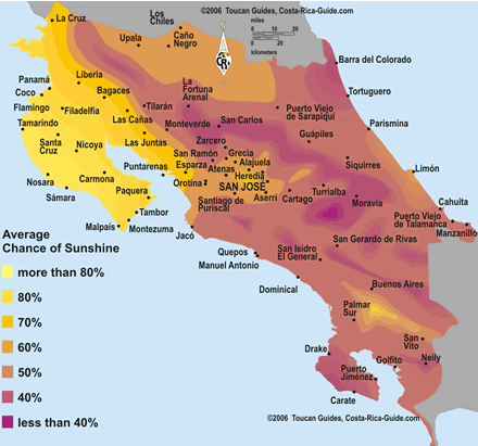
This map shows the climate throughout the country and the chances in Costa Rica that there will be sunshine on any given day. The temperatures tend to get cooler the higher up in elevation, meaning that the mountains are cooler than the flat areas of the countries.
Costa Rica Guide. (n.d.). Retrieved February 10, 2016, from http://costa-rica-guide.com/travel/weather/sunshine-temperature-map/
Costa Rica Guide. (n.d.). Retrieved February 10, 2016, from http://costa-rica-guide.com/travel/weather/sunshine-temperature-map/
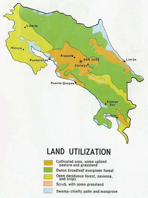
This map shows the vegetation and use of land in Costa Rica. The land usage includes forests, grass lands, fields, plantations, and all the areas in-between. This map benefits farmers, and business people, it helps people understand the location of where they want to be in the country.
Costa Rica Land Utilization and Vegetation Map. (n.d.). Retrieved February 10, 2016, from http://www.zonu.com/mapas_costa_rica/Costa_Rica_Land_Utilization_Vegetation_Map.htm
Costa Rica Land Utilization and Vegetation Map. (n.d.). Retrieved February 10, 2016, from http://www.zonu.com/mapas_costa_rica/Costa_Rica_Land_Utilization_Vegetation_Map.htm
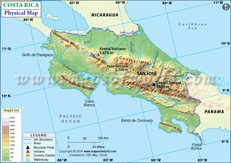
This map of Costa Rica shows the physical features of the country, including mountains, rivers, volcanos, boundaries, cities, and elevation heights. This map shows location given by the latitude and longitude. The purpose of this map is to give an idea to people about what physical features are located in specific locations throughout the country.
Physical Map of Costa Rica. (n.d.). Retrieved February 10, 2016, from http://www.mapsofworld.com/physical-map/costa-rica.html
Physical Map of Costa Rica. (n.d.). Retrieved February 10, 2016, from http://www.mapsofworld.com/physical-map/costa-rica.html
Cultural Regions
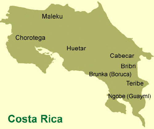
The languages on this map are all of the indigenous languages spoken in Costa Rica, the main language is not shown on the map because this is a map of only the indigenous languages. The main language spoken in Costa Rica is Spanish. Most of the country speaks Spanish, and few speak French and English. There are many languages spoken in Costa Rica that are also spoken around the world.
Costa Rica’s Invisible People: The Cabécar. (2013). Retrieved February 10, 2016, from http://www.welovecostarica.com/public/1676.cfm
Costa Rica’s Invisible People: The Cabécar. (2013). Retrieved February 10, 2016, from http://www.welovecostarica.com/public/1676.cfm
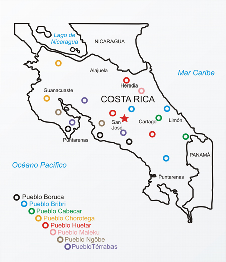
This map is of Costa Rica, and the countries and oceans that surround this. To the North is Nicaragua, to the South is Panama, to the West is the Pacific Ocean, and to the East is the Carribean. This map shows the different ethnic groups in Costa Rica, and where they are located. This map also shows the capital city of Costa Rica, San Jose. These groups are not all located in the same place. There are eight different ethnic groups through out the country, and 19 locations where these indigenous people live.
Costa Rica a corner of Paradise. (n.d.). Retrieved February 10, 2016, from http://vacationvillaquetzalojochalcr.blogspot.com/2011/09/indigenous-ancestors-of-costa-rican.html
Costa Rica a corner of Paradise. (n.d.). Retrieved February 10, 2016, from http://vacationvillaquetzalojochalcr.blogspot.com/2011/09/indigenous-ancestors-of-costa-rican.html
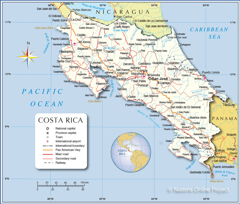
This is a map of cultural political borders within the country of Costa Rica, there is a compass rose that shows the directions, a map resembling a globe that shows where the country is, this map also shows the borders of the country, North is Nicaragua, South East is Panama, East is the Caribbean Sea, and West is the Pacific Ocean. Near the middle of the country is the capital city, surrounding it are towns, and roads. This map shows the latitudes and longitudes to determine the location of the country.
___ Map of Costa Rica. (n.d.). Retrieved February 10, 2016, from http://www.nationsonline.org/oneworld/map/costa-rica-map.htm
___ Map of Costa Rica. (n.d.). Retrieved February 10, 2016, from http://www.nationsonline.org/oneworld/map/costa-rica-map.htm
Human Landscape
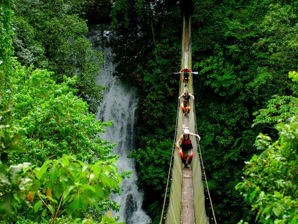
This bridge is a man made bridge where people are able to walk over the Savegre River. This river is located by Manuel Antonio National Park. Many people make the trek to this beautiful location, this bridge goes over the river right next to a large waterfall where there are many tropical animals.
Costa Rica Guide -- National Geographic. (n.d.). Retrieved February 10, 2016, from http://travel.nationalgeographic.com/travel/countries/costa-rica-guide/
Costa Rica Guide -- National Geographic. (n.d.). Retrieved February 10, 2016, from http://travel.nationalgeographic.com/travel/countries/costa-rica-guide/
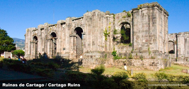
This picture is of the ruins of Cartago in Costa Rica, which were built in the 16th century. These ruins are located in a park in the central area of Cartago, Costa Rica. People used to believe that coming here would heal them, Costa Ricans patron saint was believed to be a healer in this church.
Costa Rica Explorer Guide, Costa Rica, Valle Central, Cartago. (n.d.). Retrieved February 10, 2016, from http://www.costaricaexplorerguide.com/php/subzonas.php?subzona=5
Costa Rica Explorer Guide, Costa Rica, Valle Central, Cartago. (n.d.). Retrieved February 10, 2016, from http://www.costaricaexplorerguide.com/php/subzonas.php?subzona=5
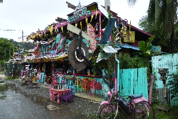
This building is in a Costa Rican village, many cities have very vibrant colors. This building has many colors, along with many items. Costa Ricans have many buildings similar to this made by boards, these boards are usually painted in different colors to attract tourist to their stands. Most of the items sold in these are handmade, ranging from glass items to jewelry.
Ramblers Worldwide Holidays - The Walking Holiday Experts. (n.d.). Retrieved February 10, 2016, from https://www.ramblersholidays.co.uk/page/natural-costa-rica
Ramblers Worldwide Holidays - The Walking Holiday Experts. (n.d.). Retrieved February 10, 2016, from https://www.ramblersholidays.co.uk/page/natural-costa-rica
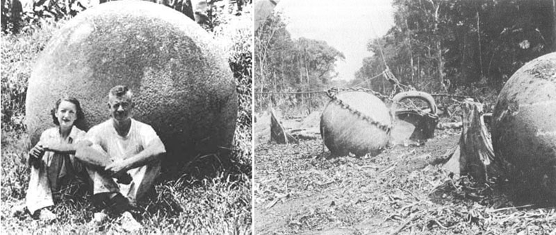
Samuel and Eleanor Lothrop investigated the stones in Costa Rica, these stones appeared and it is a mystery to people about how and when they were made. This picture was is 1948, when these two were examining the stones near the Disquis Delta.
The Stone Balls of Costa Rica. (n.d.). Retrieved February 10, 2016, from http://www.celticnz.co.nz/Costa Rica/StoneBalls1.htm
The Stone Balls of Costa Rica. (n.d.). Retrieved February 10, 2016, from http://www.celticnz.co.nz/Costa Rica/StoneBalls1.htm
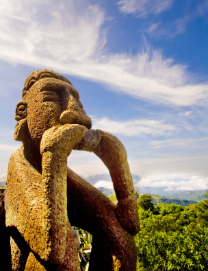
This photograph was taken near Playa Flamingo Beach in Costa Rica. This statue is a huge tourist destination, this statue is manmade out of cement. The statue sits on a hill overlooking the beach.
Playa Flamingo Beach, one of the most beautiful beaches in Costa Rica
» Tamarindo, Costa Rica | Surf Travel, Surf Reports, Ocean Conservation, Marine Life, Surfing Worldwide, Surfspots-GPS. (n.d.). Retrieved February 10, 2016, from http://surfspots-gps.com/surf-spot-tamarindo-costa-rica/
Playa Flamingo Beach, one of the most beautiful beaches in Costa Rica
» Tamarindo, Costa Rica | Surf Travel, Surf Reports, Ocean Conservation, Marine Life, Surfing Worldwide, Surfspots-GPS. (n.d.). Retrieved February 10, 2016, from http://surfspots-gps.com/surf-spot-tamarindo-costa-rica/
Physical Landscapes
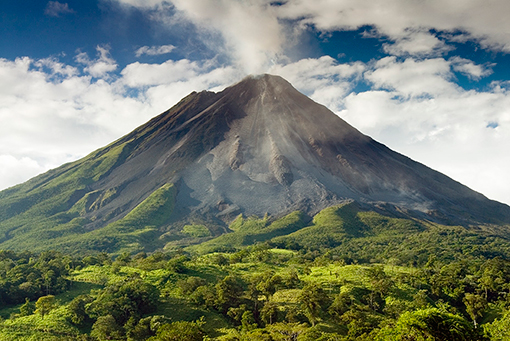
The Arenal Volcano is 5,437 feet in elevation, the bottom of the volcano is mostly greenland. This is an active volcano, it is the country's most active volcano. It has been active 43 years. The Arenal Volcano has erupted many times and has done severe damage to the land around it and people who live there.
Arenal Volcano Today's Volcanic Activity & Safe Visitation Guidelines. (n.d.). Retrieved February 10, 2016, from http://costaricaexpeditions.com/resourcelibrary/arenal-volcano-safe-visitation-guidelines.php?mnu=2
Arenal Volcano Today's Volcanic Activity & Safe Visitation Guidelines. (n.d.). Retrieved February 10, 2016, from http://costaricaexpeditions.com/resourcelibrary/arenal-volcano-safe-visitation-guidelines.php?mnu=2
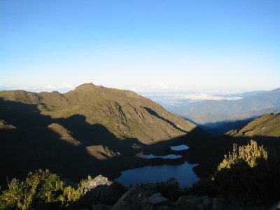
Mount Chirripo is the highest elevation spot in Costa Rica, this is the tallest mountain. The mountain is 12,533 feet tall in elevation. On the clearest days when people are standing at the peak they are able to see the entire country from the Caribbean Sea to the Pacific Ocean.
Best of Costa Rica. (n.d.). Retrieved February 10, 2016, from http://travelcostaricanow.com/index.php/Best_of_Costa_Rica
Best of Costa Rica. (n.d.). Retrieved February 10, 2016, from http://travelcostaricanow.com/index.php/Best_of_Costa_Rica
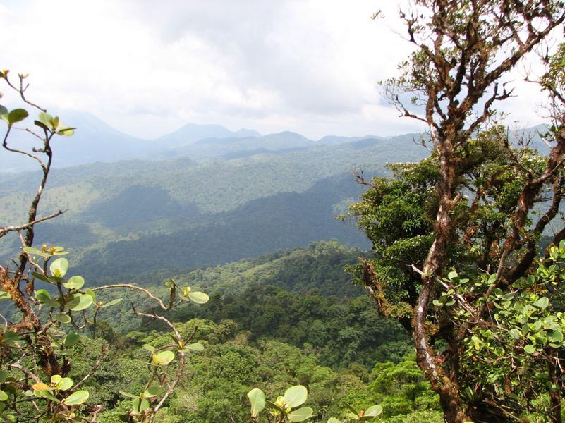
Monteverde is located at a high elevation of 4,662 feet. This location is home to many endangered species, it is also one of the greenest regions of Costa Rica. This region is full of forests, coffee plantations, local people, and endangered animals. The high elevation gives the land more moisture because of the closeness of the top point to the clouds. There are more than 100 mammal species, more than 400 bird species, and thousands of insects species. There are 420 species of orchids and over 2,500 plant species. Many people go to Monteverde to explore the canopy tours, museums, and hike on the many trails.
Photo Gallery Monteverde Cloud Forest. (n.d.). Retrieved February 10, 2016, from http://www.monteverdeinfo.com/photo_gallery.htm
Photo Gallery Monteverde Cloud Forest. (n.d.). Retrieved February 10, 2016, from http://www.monteverdeinfo.com/photo_gallery.htm
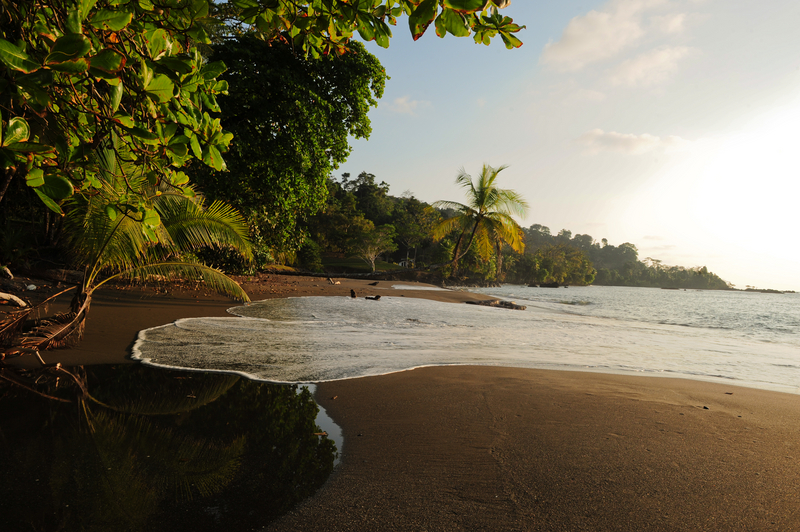
Corcovado National Park is the last part of the tropical rainforest in Central America that is on the Pacific Coast. This national park is located in Costa Rica. This picture was taken on the shore of the Pacific Ocean. Corcovado is home to more scarlet macaws than any other place on earth. Many other animals that are native to the land are still found here today that there are found nowhere else. The Bairid tapir, the harpy eagle, and the giant ant eater are all native to the Corcovado National Park.
Planning a trip to Corcovado National Park. (n.d.). Retrieved February 10, 2016, from http://www.soldeosa.com/corcovado/
Planning a trip to Corcovado National Park. (n.d.). Retrieved February 10, 2016, from http://www.soldeosa.com/corcovado/
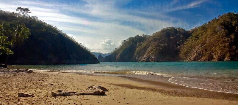
This picture was taken on the shore of Tortuga, Tortuga is an island in Costa Rica. This shore is in the Gulf of Nicoya, this island is home to many sea turtles who are native to the land. This island has more sea turtles who live here than any other area in the world does.
3D DESIGN ILLUSTRATION PHOTOGRAPHY. (n.d.). Retrieved February 10, 2016, from http://www.oscarblanco.net/landscape-photography.php
3D DESIGN ILLUSTRATION PHOTOGRAPHY. (n.d.). Retrieved February 10, 2016, from http://www.oscarblanco.net/landscape-photography.php
